

Sage_-_Beleriand_and_Eriador_collage.png (367 × 375 pixels, file size: 152 KB, MIME type: image/png)
Summary
Collage of maps (using that of Stephen Raw and Karen Wynn Fonstad's outlines) to show how Fonstad envisioned the location of Beleriand (shown submerged) relative to that of Lindon/Eriador.
Licensing
As a Tolkien Gateway contributor, Sage has granted permission to copy, distribute and/or modify this document under the terms of the GNU Free Documentation License, Version 1.2 or any later version published by the Free Software Foundation; with no Invariant Sections, no Front-Cover Texts, and no Back-Cover Texts.
It is believed that the use of this map which relates to J.R.R. Tolkien's legendarium,
- on the not-for-profit educational Tolkien Gateway website,
qualifies as fair use under copyright law in the United States of America.
File history
Click on a date/time to view the file as it appeared at that time.
| Date/Time | Thumbnail | Dimensions | User | Comment | |
|---|---|---|---|---|---|
| current | 00:28, 23 October 2010 | | 367 × 375 (152 KB) | Sage (talk | contribs) | Reverted to version as of 00:25, 23 October 2010 |
| 00:27, 23 October 2010 |  | 367 × 375 (152 KB) | Sage (talk | contribs) | ||
| 00:25, 23 October 2010 | 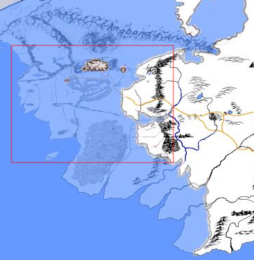 | 367 × 375 (152 KB) | Sage (talk | contribs) | ||
| 18:48, 22 October 2010 |  | 367 × 375 (150 KB) | Sage (talk | contribs) | Collage of maps (using that of Stephen Raw and Karen Wynn Fonstad's outlines) to show how Fonstad envisioned the location of Beleriand (shown submerged) relative to that of Lindon/Eriador. |
You cannot overwrite this file.
File usage
The following 2 pages use this file: